Thankfully, they have. It’s not referenced in Appendix A and therefore cannot be a part of competition fields (for now)
2 Likes
My guess would be some “guidance” will be provided in the next manual update, due 29-June-2021
7 Likes
Agreed with Foster on this one - names matter especially with technology. Telegraph and Telegram have very specific enabling technology and applications. Using their names in your application/product not great.
thumbs down on VEX’s use of GPS in their product name - does little to enable team understanding how Global Positioning System works.
What VEX has developed is a poor man approach to positioning. Why? the flaw lies in that every competition setup has huge variance of precision. Why poor man in terms of precision? Well there are assumptions about field perimeter set up. Field perimeters flex, are not guaranteed to be square from one site to another, nor during competition due to each field set up differently.
That said, VEX’s system is good to provide reference marks and the accuracy and precision will depend on teams to calibrate their software to the every changing environments for each competition. Figure it out and you are ahead of the curve. Earth surface changes all the time. This is a real world problem, just not the one described in the VEX product name.
As EP for VRC events, am I expected to put such markers up for teams that come to events with so-called VEX GPS? Moreover, as EPs doesn’t the requirement of using opaque field walls defeat the purpose of audience visibility of the event? Lots of questions about what this looks like in coming years.
18 Likes
Fine, you win. But I have to say that the naming used for VEXcode VR irks me a fair bit more than this does.
8 Likes
and to be clear - NO.
It is kind of a relative positioning system that is not guaranteed to be accurate nor precise.
An example of a better approach is a calibrated system, such as a 3D printer system that figures out the topology of the print bed before printing.
If robots had ability to map out the surface of the field they are playing, a good first approximation. The problem facing VEX teams will be accounting how the field perimeter will bow dynamically during game play.
That said - there is value of field tag recognition is huge step forward. I am absolutely certain that teams will find creative ways to use this and wow new applications of location services.
5 Likes
is it possible that the only reason this thing is vrc legal is so teams can use their vrc bot for both vrc and vexai tournaments without removing the gps? seems unlikely considering how easy that would be, but it doesn’t seem a very viable option to enforce fields to use that code.
it’s another thing that can be set up wrong, another thing teams, volunteers, and event partners have to worry about, and with arguably no benefit to the vrc program, since there are alternative and probably more reliable and educational ways to perform position tracking.
it’s not that the sensor would be too powerful for vrc, quite the opposite. I think it’s probably inferior to other methods of position tracking, making it not worth the hassle of getting all fields to be compatible with it.
(this is just my intuition speaking though, I have no idea how accurate or reliable the sensor actually is)
13 Likes
and I agree with you that naming schemes tend to cause gut reactions that really do cause us to think deeper into the problem space.
I did a lot of work in location based services with my teams in early 2000s - and we used a broad term - “Personal Radar”. It resulted in a lot of healthy debates about names, limitations of past technology implementations.
I will say name like “VEX GPS” is meant to inspire, rather than be literal. A good topic for summer thread for VEX forum.
3 Likes
So this is the other thing that I was unhappy about. There is zero description of how this works, how well it works, etc. The VEX AI program used this, but I have not seen any detailed posts about it. If they ran events, it would be good to read the results, experiences, how the programming worked, interfaces, etc.
And it looks like the plug fits the VEXIQ system, and that would be really cool!
I’m excited to hear more and use the new VEX-RPS (Robot Positioning System)
2 Likes
search for IFI patent applications, it describes in extreme detail how the sensor works.
Not exactly, last years version was based on a COTS camera and software running on the Jetson nano, this sensor is fully integrated and connects to a smart port on the V5 directly.
7 Likes
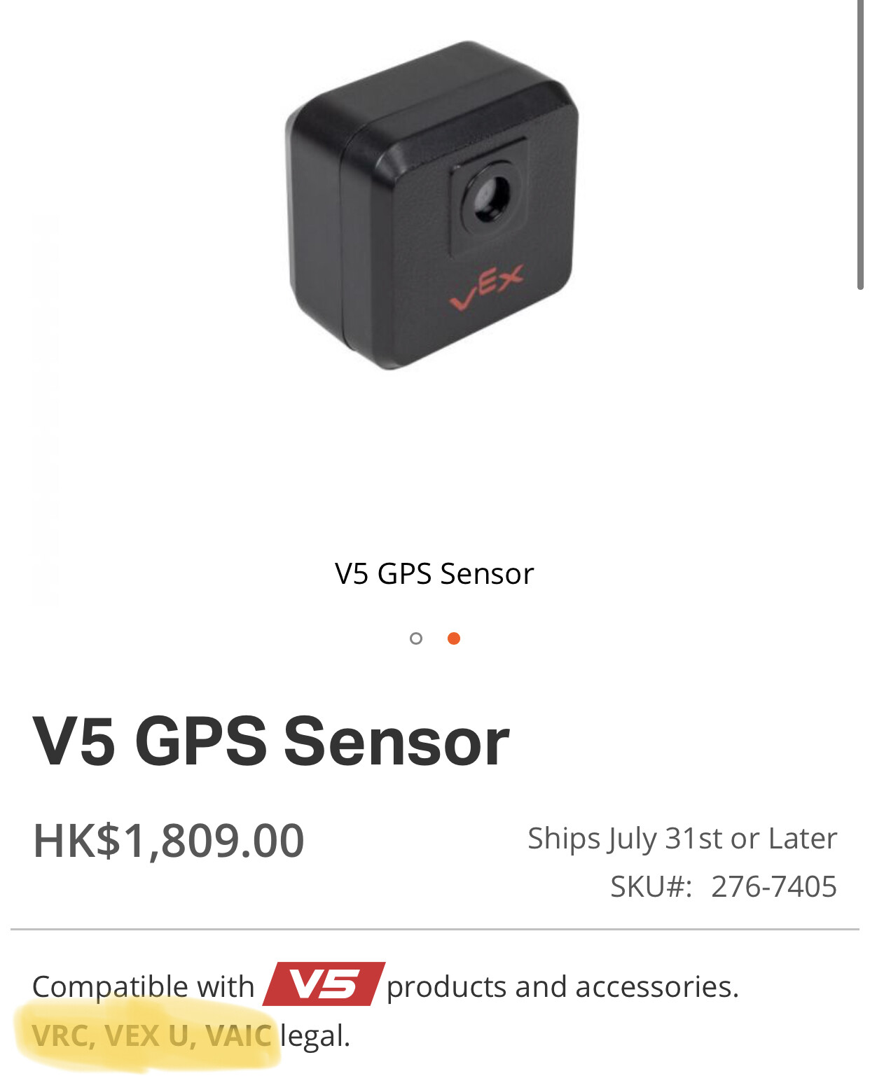
V5 only.
But it does have USB (on a USB C connector) that streams live video for debug purposes.
(images can also be seen on the V5 dashboard, not real time as such, one every second or so)
9 Likes
There are two approaches to location solutions - 1) develop specific sensors, and 2) develop sensor/device agnostic solutions to describe solutions.
The latter is the approach my team devised way back when. Back then we understood change of technology over time and changing definition of what constitutes “place” in relation of historic definitions.
Here is one patent issued for the team’s work in location based service - https://patentimages.storage.googleapis.com/4e/96/4a/0fb2b977c5c614/US7934224.pdf
1 Like
I think it’s a little early to pass judgement on the quality/accuracy/precision of the GPS sensor given that no one (outside VEX) has got their hands on it yet. We won’t have a sense of how useful it is for VRC until it ships to teams and people start playing with it. Presumably VEX is reasonably confident that the sensor will perform well, since it was developed primarily for VAIC, where having accurate & precise robot position data throughout the whole match is much more important.
Maybe some of the folks who used the GPS system in the VAIC pilot season can shed some light on how well it worked. But then again, this is v2 of that system (both the sensor and the field code), so maybe some performance improvements are to be expected compared to v1.
Even as someone who assembles and disassembles a lot of fields, this doesn’t seem like a big deal to me. The field code just attaches with velcro? Awesome, seems much easier than dealing with goal heights in change up, or assembling that cursed net structure in turning point, or any of several other minor field setup annoyances from the last few years.
Yay ![]() ! Now all we need is a revision 2 V5 brain with a USB-C port!
! Now all we need is a revision 2 V5 brain with a USB-C port!
12 Likes
2 Likes
To Foster’s point - the sensor is not GPS sensor. GPS has specific meaning in terms of implementation and precision in industry. If you want GPS accuracy, understand it deviates greatly - like 50 feet.
As for VEX implementation of their sensor and field markings that depends on how EPs put stickers up on walls, and how field perimeters are tied down will vary from field to field and competition to competition.
I do not need more info than that to say it is huge opportunity if teams are able to harness the abilities of the field positioning tags. For novice team, lots of learning to do to mitigate all these real world variances.
I do look forward to seeing how teams leverage this new sensor and field markers.
For the information available - needing opaque perimeter markers - that is not going to work for VRC events where it is expected that more visibility is better. Moreover, there is no specification of what "opaque " means in terms of consistency event to other events.
Truth be told, this is a new product announcement - be serious, many events will not have tags on field pediments, consistent opaque perimeter walls (vs transparent for audience and teams), not truly squared field perimeters that do not deviate (bend) during competition … I barely can keep field square at tile level much less at top of perimeter wall where tags are located.
I expect, because we have very clever team out there, that this so-called GPS sensor will be of competitive advantage because they can see beyond the nit-pick of past implementations of location and devise novel new approaches to this problem.
4 Likes
Transparent walls or specific opaque walls? Stock VEX GPS or some specific location hardware for just this season?
If it is the latter, then it does not help evaluate unless there is a comparison of sensor used for this event to stock sensor and field markings typical VRC events.
VAIC teams were supplied with white vinyl, VEX GPS bar code and Velcro. I’m sure there will be some image processing changes between pilot software running on the Jetson Nano and this new V5 VEX GPS sensor.
Like any sensor accuracy and noise are factors. That was our observation when we tested it out.
7 Likes
Will this or will this not be allowed for programming skills in non-AI competition? If it is allowed, then all tournaments will require the tape for their skills fields. I’d assume its AI only but there is no direct answer anywhere.
5 Likes
The site description looks like it’s VRC legal
I do not like the addition of the new sensor at all. It almost feels like the effort from teams that spent time and effort to code and develop position tracking on their own have been undermined when teams can now just pay 200$ and have global position tracking with minimal programming ability needed.
9 Likes
I just want to take this moment to thank vex for switching to USB C. We finally no longer need to deal with micro USB!
3 Likes